Flood water tracking
With the help of Flood Network, live data can be displayed showing where water levels are high or flooding is imminent.
You are currently viewing a placeholder content from YouTube. To access the actual content, click the button below. Please note that doing so will share data with third-party providers.
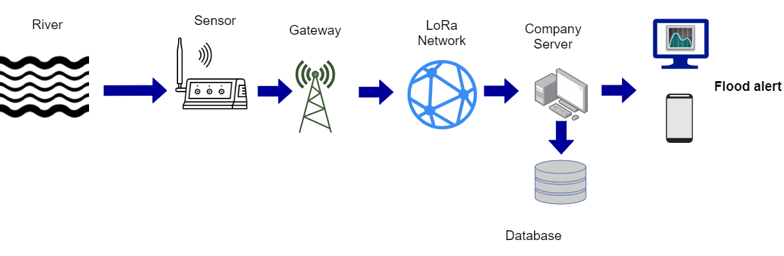
More InformationBy installing a flood sensor, data on water levels can be collected via the Internet. The low-cost wireless sensors use the power of the Internet of Things to provide up-to-date information about waterways, rivers, ditches and even groundwater. The battery-powered sensors are able to connect fully autonomously via radio to a gateway and forward collected data.
Each individual measurement consists of 15 samples from which the mean value is calculated. Invalid samples are discarded. A decision whether flooding is present or not is obtained by processing the collected raw data. These are obtained at specified sampling rates.
Goal is to quickly and easily visualize the condition of individual measurement points (bridges, bike paths, etc.) so that the corresponding situation (no flood, little water, a lot of water) can be quickly identified.
This service is available world wide. Some noteworthy locations are marked on the map
You are currently viewing a placeholder content from Mapbox API. To access the actual content, click the button below. Please note that doing so will share data with third-party providers.
More Information '
- Open source
The sensor is collecting the water level data at different locations. Using a holding device, the sensor for the measurement is suspended above the water. Any difference between the water surface and the sensor will then provide information on how high the water has risen. This sensor data than flows over the web API to the central data storage of the service provider. The data will be than provided via web service and can be viewed on the end device.